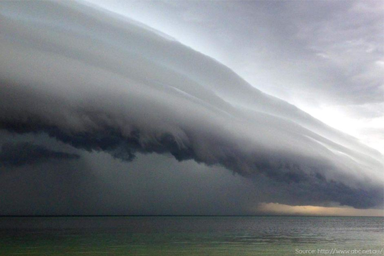
Giant bodies of air called air masses are always moving and bumping into each other. Cold air and warm air do not mix easily because they have different densities. Instead, a boundary forms between these air masses. This bounday which separates the two air masses is called a front.
An air mass is a large volume of air that is relatively uniform (horizontally) in temperature and water vapor concentration over hundreds of kilometers. Air masses are generally identified with the regions over which they develop. Two examples are continental polar and maritime tropical air masses. While air masses can persist over their formative regions for a considerable length of time, they often move across regions. As air masses move from one region to another, the air mass characteristics are modified by the underlying suface. For instance, as cold, dry "arctic air" moves over an ocean surface it gains heat and moisture.
Major weather changes occur along the boundaries between the different air masses. In reality, these boundaries are transition zones that for practical purposes can be considered as discontinuities or frontal surfaces. Owing to the general circulation of the air, the frontal surfaces are in equilibrium whenever they form a small angle with the horizontal. A frontal surface may therefore be defined as a transition-boundary separating two air masses of contrasting properties (temperature and humidity). Simply put, fronts form when one kind of air mass enters an area occupied by another kind of air mass.
Fronts can be classified geographically and also according to the motion of the air masses involved.
Geographical Classification
The formation of fronts occurs from time to time in widely different regions over the earth's surface. However, it follows from what has been said about frontogenesis that the development of fronts occurs most frequently in certain geographical regions, particularly, where deformation fields prevail with suitable temperature gradient. Regions favorable to frontogenesis are usually found along the boundaries of the four major air masses. The fronts along these boundaries are called artic, polar, and intertropical front according to their mean positions.
Classification According To Motion Of Air
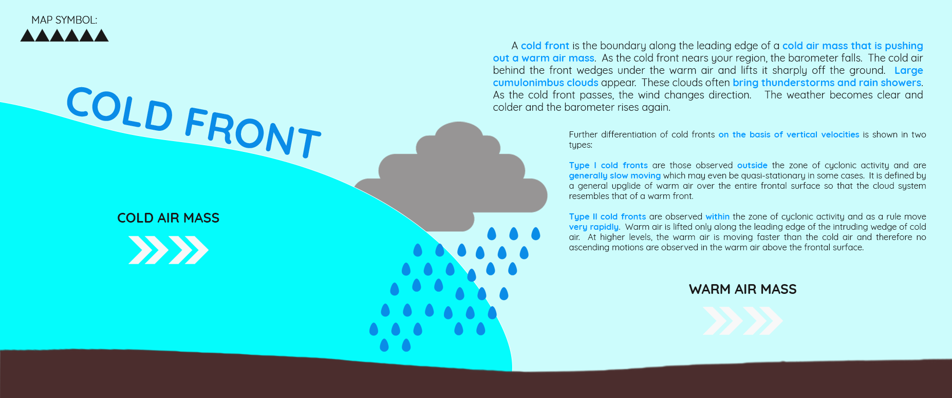
This classification is based primarily on the displacement of fronts and the resultant temperature changes. Four basic types are recognized by this classification: cold front, warm front, occluded front and stationary front.
| Characteristics | Description |
| Pressure Distribution | Active warm fronts can generally be located by pressure troughs on the surface charts. Since the troughs are seldom pronounced as those observed with cold fronts, other meteorological elements are resorted to in locating warm fronts accurately. |
| Pressure Tendencies | Pressure usually falls for an appreciable length of time prior to the frontal passage. Advection of warmer air and divergence above the frontal surface, and the removal of colder air in the lower layers account for the falling tendency. Extensive negative isallobaric patterns precede warm fronts and roughly coincide with the warm-front cloud shield. A marked decrease in the isallobaric gradient is observed in the warm sector except when rapid deepening of the associated cyclone is taking place. |
| Wind | The wind velocity usually increases in advance of warm fronts because of the general increase in the pressure gradient. Gustiness, which is noticeably absent in the underlying cold air, has been observed to increase below the warm-front altostratus deck, particularly during the cold season of the year over the continents and during the warm season over the oceans. The approach of the front is usually marked by increasing gustiness and stronger winds blowing nearly parallel to the surface front. A maximum in the wind velocity is reached just prior to the frontal passage. As the front passes, the wind will veer and generally diminish in intensity. |
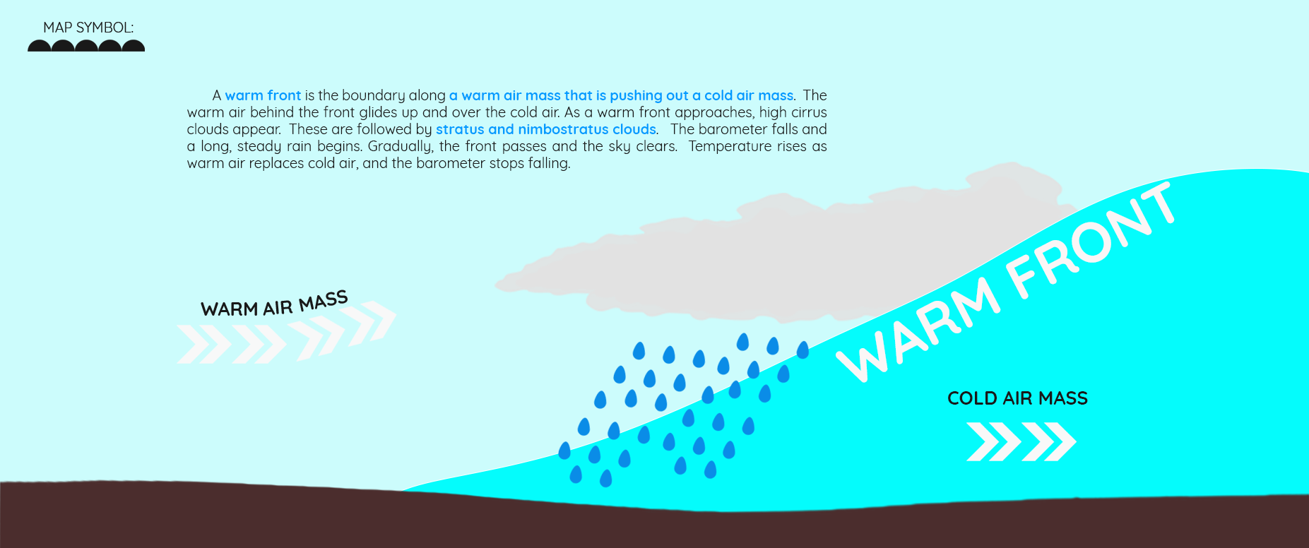
| Cloud Forms | Warm fronts are nearly always well defined by typical cloud forms. A transition from cirrus to cirrostratus to altostratus to nimbostratus is the rule. Fractostratus and stratus and occassionally fog are observed in the immediate vicinity of the warm front. Within the warm mass away from the front, only typical air-mass clouds are found. Cumulu-type clouds will form in the warm air being lifted if the air mass is convectively unstable. It is also under such conditions that mammatocumulus are observed from the ground. |
| Precipitation Forms | The precipitation area of warm fronts extends about 300 miles in advance of the surface front. Especially typical hydrometeors of warm-front precipitation are those associated with drizzle, rain, snow, and fog. |
| Temperature Changes | Temperature rises slowly with the first indications of the warm-front cloudy system. When the altostratus shield approaches and the surface inversion is destroyed, rapid increases in the surface temperature occur, often leading to the apparent development of fictitious warm front. In precipitation and fog areas, the temperature drops several degrees. When the front passes, a general and rapid rise in temperature is commonly observed. |
| Dew-Point Temperature | The dew-point temperature increases slowly with the approach of the warm front. In precipitation areas, there is a marked increase in the dew point. A further increase follows the frontal passage whenever the air in the warm sector is of maritime tropical origin. |
| Visibility | In advance of the front particularly underneath the altostratus deck, the visibility is usually good, owing to the absence of a surface inversion. In the precipitation area, the visibility decreases and becomes quite low just prior to the frontal passage. After the warm-front passage, the visibility improves to the characteristic values of the air in the warm sector. |
| Ceilings | The cloud ceilings in advance of the warm front follow the slope of the frontal surface as long as no precipitation takes place. In the precipitation area, the ceilings are lower because of clouds forming within the cold air. Very low ceilings prevail along the surface front, and a rapid improvement follows the frontal passage. |
| Indications | Description |
| Pressure Distribution | Cold fronts are located in well-defined pressure troughs whenever there is a marked density contrast between two air masses. A careful analysis of the isobars will in most cases indicate the correct position of the pressure trough that contains the front. This method of isobaric analysis is frequently the only possible means of locating fronts over ocean areas or regions of scanty surface reports. |
| Pressure Tendencies | The isallobars of falling pressure in advance of the front usually form an elongated pattern approximately parallel to the front. Cold front may indicate from weak pressure rises behind the frontal passage to sudden and strong rising-pressure tendencies following the frontal passage. The isallobars of weak rising pressure behind the front are widespread and do not show strong isallobaric gradient. On the other hand, isallobars of strong rising pressure are often confined to a narrow and oval-shaped area behind the front. |
| Wind | With the approach of the front, the wind will usually back until it is almost parallel to the front. The wind will be highest at the time of the frontal passage. A clockwise shift occurs with frontal passage. Very gusty winds and occasaionally a line squall occurs in the frontal zone. After the frontal passage, the winds decrease rapidly for weak. |
| Cloud Forms | For Type I cold fronts, towering cumulus and cumulonimbus as well as stratocumulus and nimbostratus are observed and immediately behind the surface front. Altostratus and cirrostratus usually trail far behind the surface front. Type II cold fronts are generally preceded by lenticular altocumulus that gradually increases and changes to altostratus. With the approach of the front, the altostratus merges with nimbostratus and huge cumulonimbus in a cloud bank at the front. |
| Precipitation Forms | Continuous precipitation will be observed for some hours after the frontal passage with cold fronts of type I flow conditions while showers and sometimes thunderstorms activity of short duration will occur or slightly in advance of type II cold fronts. Rapidly clearing conditions are typical after the frontal passage. |
| Temperature Changes | There is a pronounced drop in temperature with and following the frontal passage. |
| Dew-Point Temperature | The dew-point temperature will generally aid in locating fronts. The fronts are oftentimes located by the drop in dew-point temperature that will be pronounced. |
| Visibility | The approach and passage of the front is marked by decreased visibility. In the cold air, a slight improvement in visibility may be observed. However, since as long as precipitation occurs, no marked improvement takes place until the precipitation ends. The front may be preceded by regions of poor visibility due to shower activity. A pronounced improvement will almost always follow this type of cold-front passage. |
| Ceilings | The ceilings are very low at the time of frontal passage and lift only gradually after the front has passed the station. Unlimited ceilings are usually found in the cold air, thus restricting aircraft operation in the vicinity of the front, and, far in advance of the cold front, ceilings are ample for operation of the aircraft. |
Mountain ranges greatly influence the speed of fronts and frontal slopes, and the frontal activity. The orientation of the front relative to the mountain range and the size of the mountains as well as the stability of the air masses involved determine the amount of modification that develops.
The retardation of fronts in crossing mountain ranges frequently results in the development of new cyclonic waves on the front. This effect is observed on the south coast of Greenland, along the south coast of Norway, and also along the southern section of the Aleeghenies in the United States.
Warm Fronts
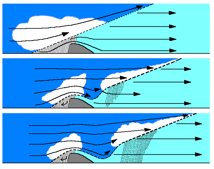
The figure represents vertical sections through a warm-front surface passing a mountain range. As a rule, the slope of warm fronts is much less than the slope of mountain ranges. Therefore, when a warm front approaches a mountain range, the warm-front surface reaches the mountain ridge first and traps a wedge of cold air along the mountainside. Since the cold mass cannot escape, the warm-front surface will accordingly become stationary along the leading slopes of the mountains. The precipitation area common to the lower portion of the warm front will then persist over the same region for a long time. The upper portion of the warm front will pass over the mountains and descend on the lee side of the mountain range. Precipitation and sometimes cloudiness are absent on this side owing to sinking motions. When the warm front arrives over flat country, it regains its characteristic cloud and precipitation pattern.
The effect of mountain ranges is therefore primarily to widen the precipitation area and to increase the duration as well as the intensity of the precipitation on the windward side of the mountains and to decrease the precipitation area and intensity on the lee side.
Cold Fronts
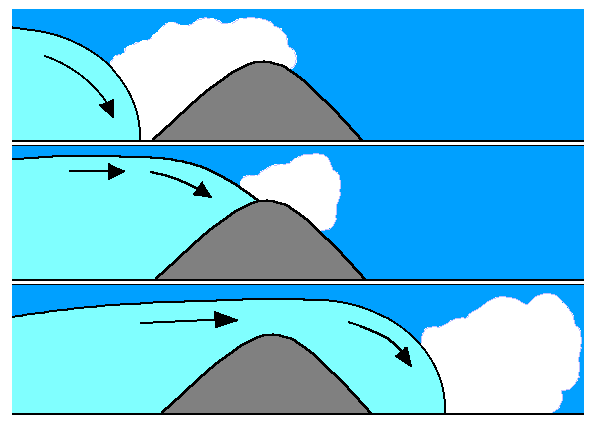
The figure shows successive vertical sections through a cold front crossing a mountain range. The cold wedge is retarded on the windward side and accelerated on the lee side of the mountains.
If the air on the lee side of the mountains is colder than the advancing wedge of cold air, the cold front will merely travel across the top of the cold dome on the lee side of the mountains as an upper-air front. This frequently happens during the winter east of the Rocky mountains and also east of the Alleghenies during the early-morning hours. At that time, the stagnant air east of the mountains will be colder because of radiation processes, while the well-stirred air associated with the cold front will maintain higher temperatures and therefore overrun the stagnant mass of the lee side of the mountains. Frontal activity will be at a minimum under such conditions until surface heating has become active in reversing the temperature conditions.
Thunderstorm conditions and squalls may develop when the upper-air front finally breaks through the ground.
If the air on the lee side of the mountains is warmer than the advancing wedge of cold air, the cold front will sweep the warm air away. The frontal activity continues unhindered in this case.
The angle with which a cold front approaches and crosses a mountain range determines the increase in frontal activity on the windward side and the relative decrease on the lee side of the mountains. The maximum change in frontal activity occurs when the front lies parallel to the mountain range.
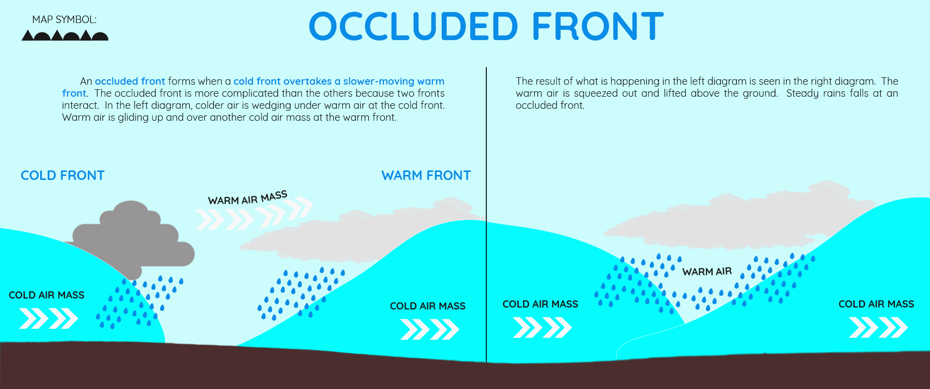
Occluded Fronts
Occluded fronts crossing the mountain ranges are influenced in the same way as cold fronts and warm fronts. Cold-front-type occlusions behave like cold fronts, and warm-front-type occlusions cross mountain ranges like warm fronts.
Mountain ranges frequently tend to accelerate the occlusion process when a warm-sector cyclone approaches. Under such circumstances, the warm front is retarded by the mountain range while the cold front moves unhindered until it reaches the mountain range and the stalled warm front. This condition is observed often on the west coast of continents during winter.