Heavy Rainfall Warning No. 5 #NCR_PRSD
Weather System: Southwest Monsoon (Habagat)
Issued at: 11:00 PM, 05 July 2025(Saturday)
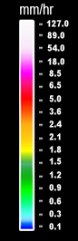
YELLOW WARNING LEVEL: Zambales.
ASSOCIATED HAZARD: FLOODING in flood-prone areas.
Meanwhile, expect light to moderate rains over Tarlac, Pampanga, Bulacan and Nueva Ecija within the next 3 hours.
Light to moderate with occasional heavy rains affecting Bataan which may persist within 3 hours.
The public and the Disaster Risk Reduction and Management Offices concerned are advised to MONITOR the weather condition and watch for the next warning to be issued at 2:00 AM tomorrow.
For more information and queries, please call telephone numbers 8927-1335 and 8927-2877 or log on to www.pagasa.dost.gov.ph.
Heavy Rainfall Warning No. 5 #NCR_PRSD
Weather System: Southwest Monsoon (Habagat)
Issued at: 11:00 PM, 05 July 2025(Saturday)
YELLOW WARNING LEVEL: Zambales.
ASSOCIATED HAZARD: Possible FLOODING in flood-prone areas.
Meanwhile, expect light to moderate rains over Tarlac, Pampanga, Bulacan and Nueva Ecija within the next 3 hours.
Light to moderate with occasional heavy rains affecting Bataan which may persist within 3 hours.
The public and the Disaster Risk Reduction and Management Offices concerned are advised to MONITOR the weather condition and watch for the next warning to be issued at 2:00 AM tomorrow.
For more information and queries, please call telephone numbers 8927-1335 and 8927-2877 or log on to www.pagasa.dost.gov.ph.
Thunderstorm Watch #NCR_PRSD
Issued at: 10:00 PM, 05 July 2025
Thunderstorm is MORE LIKELY to develop over Greater Metro Manila Area(Metro Manila, Bulacan, Rizal, Laguna and Cavite) within 12 hours.
All are advised to continue monitoring for updates.